Update of the National Emergency Planning for Vesuvius
The dossier contains the description of the path that led to the definition of the new red zone, of the new yellow zone and of the evacuation and transfer plan of the population from the red zone.
This dossier is dedicated to the update of the National Emergency Plan for the Vesuvius.
In 2014, after a long process of study and analysis, we came to the identification of the new red zone, i.e. the area for which the evacuation is the only preventive measure of the population. At the same time, twinnings were also redefined with the Regions and the Autonomous Provinces that will host the evacuated people. In 2015, the new yellow zone was approved, i.e. the area outside the red zone exposed to the significant fallout of volcanic ash and pyroclastic materials. The plan for the removal of the population of the red zone is currently being developed by the Campania Region, with the support of ACaMIR - Agenzia Campana Mobilità Infrastrutture e Reti.
For the time being, the Campania Region has identified, within the activities of the working table coordinated by the Department of Civil Protection and composed of all the bodies has defined the general strategy for the transfer of the population to the twinned Regions and Autonomous Province
The red and yellow zones have been identified by the Department of Civil Protection, based on the recommendations of the scientific community, and in collaboration with the Campania Region. The starting point for the update of these areas was the document prepared by the working group "Scenarios and alert states" of the National Commission, established in 2003 to provide for the update of the National Emergency Plan for the Vesuvius and Campi Flegrei areas.
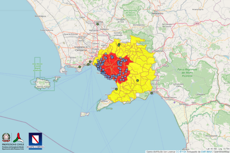
The new red zone, unlike the one identified in the 2001 Plan, includes, in addition to an area exposed to the invasion of pyroclastic flows (red zone 1), also an area subject to high risk of collapse of the roofs of the buildings due to the accumulation of pyroclastic deposits (red zone 2). The redefinition of this area also includes the involvement of a number of municipalities that have been able to indicate, in agreement with the Region, which part of their territory will fall in the area to be evacuated out of prevention. Other municipalities were instead considered entirely on the basis of their administrative boundaries. The new red zone includes the territories of 25 municipalities in the provinces of Naples and Salerno, that is 7 municipalities more than the 18 provided for in the National Emergency Plan of 2001. The Directive of 14 February 2014 has identified the twinning between the towns of red zone and the Regions and Autonomous Provinces that will host the evacuated population. In addition, as required by the directive, March 31, 2015 were published in the Official Gazette of the operational guidelines on the basis of which components and operational structures of the National Service will have to update their emergency planning according to the red zone. These operational guidelines are contained in a decree of the Head of the Civil Protection Department and were developed in consultation with the Campania Region, and after consultation with the Joint Conference (joint headquarters of the State-Regions and of the State-city and local governments).
In the new yellow zone, made official with the Directive of the President of the Council of Ministers on the Official Gazette on January 19, 2016, fall instead 63 municipalities and three districts of the Municipality of Naples. The definition of this area is based on recent studies and simulations of the distribution on the ground of volcanic ash produced by sub-Plinian eruption, which is the reference scenario for upgrade planning, and takes into account the historical statistics of the wind altitude. In particular, the yellow zone includes the territories for which it is necessary to plan the intervention of national and regional level to manage a possible emergency; in their territory, in fact, it is likely, that a quantity of ashes fallen may be such as to cause the collapse of the roofs, and this constrains the municipalities that are part of it to adapt their emergency planning. The fallout of volcanic ash can produce, locally, other consequences (such as the clogging of sewers and the difficulty of movement of vehicles) that may also affect a very large area, outside the yellow zone. Even these municipalities will have to update their emergency planning. Operational guidelines for updating the emergency planning for the yellow zone are expected to be issued, as done previously for the red zone.
This dossier will be constantly modified to tell all the stages that led to the update of the National Emergency Plan. The first page retraces the path of the work of the National Commission since 2003; the second presents a synthesis of the reference event for the plan and alert levels; the third details the redefinition of the red zone; the fourth presents the new scheme of twinnings between Municipalities in the red zone and Regions and Autonomous Provinces and explains briefly the Plan for transferring people from the red zone; the fifth is dedicated to the new yellow zone.
Latest update: 31 August 2018
2003 - Reconstitution of the National Commission
2006 - Mesimex International Exercise on Mount Vesuvius
2007/2008 - Changes made to the Plan
2012 -The new scenario for the National Plan
2012 - Alert levels for the new plan
2012/2013 - Training activities on volcanic risk in the Vesuvius area
2013/2014 - Definitive delimitation of the red zone and twinnings
2014 - Training activities in the Vesuvius and Phlegrean Fields areas
2015 - New yellow zone and addresses to operating components and structures for the red zone
2016 - Publication of the resolution of the President of Council that officialises the yellow zone
2016/2017 - Presentation of the Plan to evacuate people from the red zone
2017/2018 – Intervention model to activate in case of yellow, orange or red alert
2003 - Reconstitution of the National Commission. The first National Emergency Plan for Vesuvius was drafted in 1995 by two national commissions, set up in 1991 and 1993, to assess the risk involved in the Vesuvius eruption and plan the response to any emergency. In 2001, the "Additions and Variations" in different sections of the Plan were approved. In 2002, a National Commission is reconstituted with the goal of having an ordinary instrument for the continuous updating of the planning and the Head of the Department of Civil Protection, by decree no.698 of 6 March 6 2003, he appoints the members. In particular, the Working Group made up of experts in volcanic risk is entrusted with the revision of the scenarios and levels of alert for a national emergency.
2006 - Mesimex International Exercise on Mount Vesuvius. A first test of the activities carried out by the new Commission was organized in 2006, with the international exercise Mesimex - SIMulation Major Emergency Exercise - a volcanic eruption of Mount Vesuvius was simulated to test and improve emergency procedures, including 'evacuation of the inhabitants of the towns in the red zone. The Civil Protection Department coordinated the exercise that involved four EU member states - France, Spain, Portugal and Sweden, testing their ability to respond within the European Civil Protection Mechanism. In particular, during the exercise, the viability plan for the Vesuvius area has been tested. The plan was prepared in 2006 by the Civil Protection Department, in collaboration with Hydraulics Traffic and Transport Department of La Sapienza University of Rome, which set out the main evacuation routes from towns in the red zone in case of eruption.
2007/2008 – Changes made to the Plan. Following the exercise, some changes to the National Plan of emergency for the area of Vesuvius were introduced in 2001, shared at a meeting of 23 April 2007 by the Civil Protection Department, Vesuvius Observatory Ingv Region Campania, Prefecture - Utg and the Province of Naples. The changes introduced were not made official in the updated document because in 2006 it was already in the activities of the group, responsible for defining the new scenario, which would have formed the basis for a comprehensive review of the Plan. In particular, during the meeting the following were confirmed: a sub-Plinian eruption as a reference event, the definition of red zone established in 2001, the three levels of warning before an eruption - attention, pre-alarm, alarm. On the other hand, the need to redefine the yellow area, i.e. the area subject to the fallout of ashes and lapilli, and the blue area, potentially subject to flooding and flooding, as well as to the fallout of ashes and lapilli, was highlighted. With regard to the operational measures envisaged in the Plan, twinning was confirmed between Vesuvian municipalities and Italian regions for the hospitality of the evacuated population. Evacuation of health care facilities and launching initiatives to safeguard the cultural heritage are now again considered part of the pre-alarm phase, whereas the alarm phase includes the evacuation of the red zone within 72 hours and no more than 7 days, as provided in the Plan of 2001. What emerged was the importance of redefining how the evacuation of the population would be carried out, according to the measurements in the Traffic Plan. In particular, the evacuation has been organized in two phases: the first one provides for the displacement of the population in areas of first aid immediately outside the area at risk (red and yellow zones), and a second one which provides for the transfer in the twinned regions . The means chosen for evacuation are road transport, and other means (trains and ships) are kept as a strategic reserve.
(The Traffic Plan and its attachments are available in the annex, whereas the tables relating to the Plan are not published because the files are too heavy for the website. However, they can be obtained from the Department.)
At the same meeting, lines under the responsibility of various local administrations involved were also defined, with particular reference to the population census and reception facilities and evacuation plans in detail. After the meeting, Department, Region,
Prefecture - Utg and the Province of Naple organized various meetings with municipal technicians in the red zone to agree on the plan for general traffic, accepting any additions and amendments proposed by local governments, where possible.
2012 – The new scenario for the National Plan. On 26 April 2012 the Department has received from the working group of the National Commission for the emergency plan a document regarding new scenarios and alert levels, on the basis of which the different risk zones and their operational strategies will be redefined. The document of the scenarios was submitted on 27 June 2012 for the assessment of the National Major Risks Commission - Sector Volcanic Risk that was found consistent with the most recent studies on the topic. From this moment on, the Department has initiated a series of discussions with the Campania Region to collect the information necessary for redefining the red zone, which now includes the territories of 25 municipalities in the province of Naples and Salerno. In particular, the area includes the area to be evacuated in danger of invasion by pyroclastic flows (the red 1) and the area at high risk of collapse of the roofs of the buildings for the accumulation of volcanic ash and lapilli (red zone 2) . On 19 December 2012 the new scenario was presented to municipalities in the red zone in the Vesuvian area then be shared with the national operating structures, on 11 January 2013. during an operational Committee.
The Working Group also has studied in-depth the ash fallout, using the results of several scientific works and projects, and has identified possible scenarios of reference for the definition of the yellow zone.
The attachment “Scenario and alert levels” published on 11 January 2013 has been substituted on 6 February 2013 with a easy-reading, in colour, with a new lay out document. The number of pages has been halved, because we mistakenly duplicated the document. We specify that the content is exactly the same of the old one.
Tables and charts referred to in the document “Eruptive scenarios and alert levels” are not attached because they are too heavy. The Department can provide them to any institution upon request.
2012 – Alert levels for the new plan. The working group has decided to maintain the same level of alert in the Plan of 2001, which includes a basic level (green), a level of attention (yellow), a level of pre-alarm (orange) and a warning level (red), in accordance with the provisions of the most monitored volcanoes on our planet. The four levels of alert mark the time before a possible resumption of eruptive activity occurs. Currently, the alert level to Vesuvius is green, that is there has been no abnormal phenomenon than ordinary activity that has been characterizing the volcano for decades. The transition from one level of alert to the next corresponds to the variation of the parameters (seismicity, ground deformation, the composition of gases in fumaroles, etc..) routinely monitored, 24/7, by the monitoring system managed by the Vesuvius Observatory - Ingv and leads to a progressive increase in the probability of reactivation of the volcano eruption.
Consequently, it modulates the increasing response of the civil protection system, which culminates with the evacuation of the population present in the red zone (alarm level). The definition of specific preset thresholds, beyond which are activated "automatically" the various levels of warning, it is a complex and delicate operation. According to the findings of the Working Group for the transition from the basic level to the level of attention it is possible to establish a threshold, that is, a quantitative criterion based on overcoming the basic values of the monitored parameters: the variation of a parameter is considered significant when it exceeds the value ordinarily recorded (end value) of at least twice the value of its standard deviation (uncertainty associated with the figure). In particular, it is established that the transition to the level of attention occurs when at least two of the monitored parameters have recorded significant variations. If the change occurs only for a parameter that does not imply a change to the level of attention but activates a phase of exceptional surveillance for the entire surveillance system and the Central Functional Centre of the Department. For the higher levels of alert it is believed that the definition of predetermined thresholds involves a high probability of false and missed alarms, so the assessment should be based on an analysis of the parameters monitored in real time by experts.
2012/2013 - Training activites on volcanic risk in the Vesuvius area.The Department of Civil Protection, the Campania Region and the Vesuvius Observatory launched in late 2012 training courses on volcanic risk dedicated to municipalities, volunteers and operational structures of the Phlegraean and Vesuvius areas, and staff the Campania Region, the Prefecture and the Province of Naples. The course included two days lectures and two days dedicated to the visit of Phlegraean Fields, Vesuvius and the Vesuvius Observatory. All municipalities in the Phlegraean Fields - Bacoli, Giugliano in Campania, Marano, Pozzuoli, Quarto and Monte di Procida - have joined the initiative while in the Vesuvius area only twelve municipalities have participated in the training days: Ercolano, Massa di Somma, Nola, Poggiomarino, Pollena Trocchia, Pompei, Portici, Somma Vesuviana, Terzigno, Torre Annunziata, Torre del Greco and Pompei. About forty officials attended the edition dedicated to the staff of the Campania Region and the Municipality, Prefecture and the Province of Naples, while 30 voluntary organizations of the Vesuvius and the Phlegraean areas took part in the fourth training cycle. For 2013, there are additional editions of the updating emergency plans for the two volcanic areas.
2013/2014 – Definitive delimitation of the red zone and twinnings
In order to define the new red zone, from the perspective of sharing and collaborating with every and each involved subject in the national planning, it has been agreed that, if the municipalities were able to manage partial evacuation of their own communities, they could have propose boundaries different from the administrative ones set up by the Department (see map New scenario Vesuvius(905 Kb)"). To carry out such new boundaries, the Department imposed two conditions: that the proposed boundaries were not smaller than the ones defined by the “red zone 1”, that is the one subject to the invasion of pyroclasting flow; that the Municipalities with territories in the red zone 2 could demonstrate to have reinforces the roofing of vulnerable buildings exposed to the fall of pyroclastic deposits.
Only a few municipalities made proposals that were accepted by the Regional Committee with the 26 July 2013 decision. The new red zone (436 Kb) was permanently approved on 14 February 2014 in the directive of the President of Council of Ministers, that received the approval of the Joint Conference on 6 February 2014.
In the same directive, to guarantee assistance to the population in the red zone, the twinning to carry out between municipalities and Regions and Autonomous Provinces in case of precautionary evacuation has been redefined.
2014 – Training activities in the Vesuvius and Phlegrean Fields areas
At the end of the year , the Department of Civil Protection and INGV-National Institute of Geophysics and Volcanology have started, with the collaboration of the Regional Education Office and the Campania Region, the EDURISK project in primary and secondary schools of the red areas of Vesuvius and Phlegrean Fields. It is a training for teachers which provides specific tools to support educational planning. Among the topics covered: hazard and assessment of seismic and seismic risks; psychology and behavior in contexts of volcanic risk; risk education. A part of the training is dedicated to the presentation of the National Service of Civil Protection and Emergency Planning for Volcanic Risk.
2015 – New yellow zone and addresses to operating components and structures for the red zone
On 9 February, the Campania Region has approved the resolution with new borders of the yellow zone. This area, outside the red zone, is exposed to a significant fallout of volcanic ash and pyroclastic materials that could cause the collapse of the roof. The resolution welcomes the definition given by the Civil Protection Department, based on indications of the scientific community, and in collaboration with the Campania Region. In the same resolution, were also supplied indications for the preparation of emergency plans to municipalities in the yellow zone and also to those outside of it but still affected, although to a lesser extent, from the fallout of volcanic ash that could result, locally, other consequences (such as the clogging of sewers, the difficulty of vehicle circulation, the interruption of power lines and communications).
In addition, as required by the Directive of 14 February 2014, on 31 March 2015, the indications of the Head of Department have been published in the Official Gazette, in agreement with the Region of Campania and after consultation with the Joint Conference, addressed to the members and operating units in order to update within 4 months their emergency planning in relation to the red zone.
2016 - Publication of the resolution of the President of Council that officialises the yellow zone
On 19 January 2016 the directive of the President of the Council of Ministers which establishes the new yellow zone has been published on the Official Gazette, already approved on 9 February 2015 with directive of Campania Region. The Head of Department, in agreement with Campania Region, and the Joint Conference, provides to the components and operational structures of civil protection the indications for the update of the respective emergency plans, aiming at safeguarding the population in the yellow zone.
2016/2017 – Presentation of the Plan to evacuate people from the red zone
The Campania Region is developing - with the support of ACaMIR - Campana Mobility Infrastructures and Networks Agency and in close connection with the Department of Civil Protection and with the managers of infrastructural networks - a Plan to manage the removal of people to be evacuated in precautionary way from the 25 municipalities of the red zone. In summary, the Plan provides for the identification of "gates" for the exit from the red zone and the assisted transport of the population in "meeting areas", identified along the main escape routes. The general strategy of the phase of transfer of the evacuated population - which will take place by bus, train or ships - from the "meeting areas" to the "first reception points", set up in the regions and autonomous twinned provinces, has already been planned. To guarantee the homogeneity of the Red Zone population transfer plans in the different regions and autonomous autonomous provinces, a working table was set up by the Department, which was attended by the bodies and companies with competence in the management of national mobility. The meeting areas, together with the transfer procedures, have been formalized with the Campania Region Resolution n. 8 of 17 January 2017.
2017/2018 – Intervention model to activate in case of yellow, orange or red alert
In conjunction with the Campania Region, the Department of Civil Protection has developed a model of intervention to be activated in case of passage from the current state of equilibrium (green) to the levels of yellow, orange and red alert, with the consequent activation of the different operating phases (attention, pre-alarm and alarm). The model defines, in particular, the organization of the National Civil Protection Service for the execution of the operational activities necessary to manage any emergencies (from the activation of the Operational Committee, to the structuring of the Di.Coma.C and the operational and coordination on the territory). This document has already been shared with the components and operational structures of civil protection and, soon, will be formalized in a specific document that will define the details.
Latest update: 31 August 2018
The landmark event. The document "Scenarios and alert levels for the Vesuvius" delivered from the National Commission identifies an explosive sub-Plinian eruption as a reference event for the National emergency Plan for the Vesuvius, confirming what was already assumed in the 2001 Plan.
This scenario envisages:
• the formation of an eruptive column of several kilometers;
• the fall of volcanic bombs and blocks around the crater and smaller particles (ash and lapilli) up to several tens of kilometers away;
• the formation of pyroclastic flows that would flow down the volcano's slopes for a few kilometers.
Seismic activity may precede the eruption and accompany the different phases, causing particularly serious damage to buildings already burdened by the load of products launched in the first phase of the eruption.
The eruptive scenarios expected. For the definition of the reference scenario, we have evaluated the probability of occurrence of different scenarios, corresponding to three types of explosive eruptions (with Plinian volcanic explosivity index VEI = 5, sub-Plinian eruption with VEI = 4 and violent Strombolian VEI = 3).
On the basis of statistical studies, for the Vesuvius an event of less energy (VEI = 3) would be more likely (slightly above 70%), however, the experts considered that scenario to be taken as reference should be an explosive sub-Plinian eruption with VEI = 4 for the following reasons:
• has a conditional probability of occurrence that is quite high (slightly less than 30%);
• corresponds to a reasonable choice of "acceptable risk" given that the probability of this event will be exceeded by Plinian eruption with VEI = 5 is only 1%;
• geophysical data do not reveal the presence of a shallow magma chamber with sufficient volume to generate a Plinian eruption type.
Areas at risk planned for a sub-Plinian eruption, taken as the reference scenario for the new Vesuvius Plan, cover also those for Strombolian eruption, of less energy.
However, we underline that despite having been identified a sub-Plinian eruption as a key event, the present state of knowledge - should phenomena linked to a possible reactivation occur - it would not be possible to determine what type of possible eruption will be from the analysis of the precursors.
The hazard areas. On the basis of the reference scenario and of the different hazard areas two zone of the Plan (yellow and red) have been defined ,for which different operating measures are envisaged. New specific operational indications will be elaborated to manage any effect connected to flooding phenomena and invasion caused by mud slides (lahar)
The alert levels. The working group has decided to maintain the same alert levels provided in the 2001 Plan, which are a basic level (green), a level of attention (yellow), a pre-alarm level (orange) and an alarm level (red), in accordance with the provisions for most of the monitored volcanoes on our planet. The four levels of alert mark time before a possible resumption of eruptive activity.
Currently, the alert level of Vesuvius is green, which means that there has been no abnormal phenomenon compared to the ordinary activity that has characterized the volcano for decades. The transition from one level of alert to the next one corresponds to the variation of the parameters (seismicity, ground deformation, composition of the gas in the fumarole, etc.) routinely monitored, 24/7, managed by the monitoring system of the Vesuvius observatory of Ingv and it involves a gradual increase in the probability of eruption of a reactivation of the volcano. Consequently, the increasing response of the civil protection system is modulated in accordingly, which culminates with the evacuation of the population present in the red zone (alarm level).
Latest update: 31 August 2018
The "red zone" is the area for which preventive evacuation is the only measure of protecting citizens. Unlike the one identified in the 2001 Plan, the new red zone includes, besides an area exposed to the invasion of pyroclastic flows, defined as "red zone 1", also an area subject to high risk of collapse of the roofs of buildings due to the accumulation of pyroclastic deposits (volcanic ash and lapilli), defined as the "red zone two".
Studies at the base of the redefinition of the red zone. The Working Group of the National Commission, which was responsible for the update of the Vesuvius Emergency Plan, has redefined the extent of the area exposed to pyroclastic flows, highlighting the necessity that the limits of the new red zone were expanded compared to the current Plan. The Major Risks Committee-Volcanic risk Sector, called by the Civil Protection Department to express an opinion on the matter, has compared the area identified in the document with the most recent studies on the topic. In particular, the results of the Working Group were compared with the line that identifies the area subject to average frequency of invasion by pyroclastic flows outlined in the 2010 scientific publication of Gurioli et al. "Pyroclastic flow hazard assessment at Somma Vesuvius based on geological record”, deeming the studies broadly consistent. For the identification of areas exposed to a high risk of collapse of the building roofs, the results of the Project SPeeD were also considered , as they combined the analysis of load curves of the deposit of ash fallout with vulnerability data of the building rooftops.
List of municipalities in the red zone. As a result, the new red zone has been expanded, compared to that provided for in the 2001 Plan, including the territories of 25 municipalities. In addition to the 18 already indicated in the red zone (Boscoreale, Boscotrecase, Cercola, Ercolano, Massa di Somma, Ottaviano, Pollena Trocchia, Pompei, Portici, Sant’Anastasia, San Giorgio a Cremano, San Sebastiano al Vesuvio, San Giuseppe Vesuviano, Somma Vesuviana, Terzigno, Torre Annunziata, Torre del Greco, Trecase), the following have been entirely included: Palma Campania, Poggiomarino, San Gennaro Vesuviano and Scafati and, only partially, the districts of Barra, Ponticelli and San Giovanni a Teduccio of the Municipality of Naples, the Municipality of Nola and the enclave of Pomigliano d’Arco in the Municipality of Sant’Anastasia.
Redefinition of the boundaries of the new red zone. In the first updated version of the National Emergency Plan outlined by the Department, the 24 municipalities and 3 districts of Naples were entirely included in the "red zone", taking as reference the administrative boundaries. The decision of the Department to consider the municipal limits - or of the municipality, in the case of Naples - is linked to the need to integrate, at a later stage, detailed operational information of the territory. For this reason, also in view of sharing and collaboration between all those involved in national planning, each municipality, in agreement with Campania Region, was asked to propose for the their territories, new boundaries of the "red zone" , as long as they proved to be able to handle partial evacuations of their communities. To carry out the new borders, the Department put down two conditions: that the boundaries were not smaller than the ones of the “red zone 1”, which is the one subject to the fall of pyroclastic flows; that the Municipalities in the red zone 2 could demonstrate to have reinforced the building rooftops exposed to the fall of pyroclastic deposits.
However, the Department deems appropriate that the 18 municipalities already listed in the old Plan keep the administrative boundaries as perimeter of the red zone, due to the achieved awareness over the years by such communities to live in an area exposed to a high volcanic risk and the effort carried out by some local boards to adopt proper prevention measures.
Three municipalities have proposed new boundaries: the City of Naples, the City of Nola and Pomigliano d'Arco. For all other municipalities, administrative boundaries are considered as boundaries of the new red zone. The proposed changes were accepted by the Regional Council with the July 26, 2013 deliberation, and subsequently approved on 14 February 2014 in the Prime Minister's Directive, which was received by the Joint Conference on 6 February 2014.
Planning of operating structures and components of the National Service. As provided for by the 14 February 2014 directive, on 31 March 2015 the decree of the Head of Department of civil protection that contains the operating instructions that the National Service's components and structures should follow to update their respective emergency plans in case of evacuation of the red zone. In fact, only when the criteria and the general strategies will be applied in the planning of all involved parties, the National Emergency Plan can become a truly operational tool.
Specifically, the directions are divided into six different sections. After a part describing the general strategy that all National Service will need to follow in the operational stages corresponding to levels of alert attention, pre-alarm and alarm, the document contains the addresses for internal, sectorial and communication planning. In particular:
- internal planning provide for procedures and actions for the protection of human resources and tools that each component or operational structure has in the red zone
- planning of the sector will ensure the response of components and operational structures at various operational stages and the integration and harmonization of the actions of the various government departments and agencies to achieve the overall objectives
- communication plans provide a schedule of information and communication activities of components and operational structures at different stages.
The document defines also the necessary elements for the Campania Region, local authorities concerned and to the regions and autonomous provinces to develop plans to evacuate the population from the red zone and transfer and welcome them. Specific indications are given also to the Region Campania and local authorities to upgrade their emergency planning. One chapter is dedicated to the planning and general coordination for which the Civil Protection Department is in charge, while the last part of the document provides elements for ensuring the continuity of local authorities.
Latest update: 31 August 2018
Tables and charts referred to in the document “Eruptive scenarios and alert levels” are not attached because they are too heavy. The Department can provide them to any institution upon request.
Twinning scheme. To guarantee assistance to the population of the municipalities in the red zone, in the directive of the President of the Council of Ministers of February 14, 2014, the twinning scheme to be implemented between these municipalities and the Regions and the Autonomous Provinces in the case of preventive evacuation was redefined.
The twinning scheme envisages that the population of Portici will be assisted in Piedmont; of Nola in Valle D'Aosta; of Cercola in Liguria; of Torre del Greco and Somma Vesuviana in Lombardy; of Pollena Trocchia in Trentino Alto Adige; of San Giuseppe Vesuviano, Sant'Anastasia (including the enclave of Pomigliano D'Arco) in Veneto; of Palma Campania in Friuli Venezia-Giulia; of Ercolano in Emilia Romagna; of San Giorgio a Cremano in Tuscany; of San Gennaro Vesuviano in Umbria; of Poggiomarino in the Marche; of Ottaviano and the districts of Naples in Lazio; of Terzigno in Abruzzo; of Massa di Somma in Molise; of Torre Annunziata and San Sebastiano al Vesuvio in Puglia; of Boscotrecase in Basilicata; of Boscoreale in Calabria; of Scafati and Trecase in Sicily; and Pompeii in Sardinia. In order to make twinning operations operative, the Regions and the Autonomous Provinces will have to sign memorandums of understanding with the Campania Region and the municipalities in the red zone, in agreement with the Department.
Evacuation plan for the population from the red zone. In order to regulate the displacement of the people to be evacuated, an evacuation plan of the population has been drawn up. The document was drafted with the aim of carrying out the evacuation in 72 hours, with a simultaneous departure and divided into phases from all the Municipalities of the red zone, in the precautionary hypothesis that the removal, both spontaneous and assisted, of all its 670 thousand inhabitants occur simultaneously (and that there have therefore been no previous spontaneous departures). In particular, the assisted movement of people from the "waiting areas", defined in the Civil Protection Plan of each Municipality, to the "meeting areas", identified just outside the red zone, will take place with coaches made available by the Campania Region while the their transfer to the "points of first reception" in the Regions and autonomous twinned provinces can take place in different ways (coaches, trains or ships) depending on the destinations, to limit the load on the mobility infrastructure and the inconvenience to the population. People can also choose to move independently, with their own means of transport. In this case, they will be able to do so by following the road exits from the red zone established in the plan and then proceed directly to the "First Reception Points" identified in the twinned Regions and Autonomous Regions. In both cases, however, the exit from the red zone will have to take place through the "gates" identified in the Plan.
The "Meeting Areas" together with the transfer modalities of the population from the red zone have been formalized with the decision of theCampania Region n.8 of 17 January 2017.
The Plan for the evacuation of the population of the red zone is being developed by the Campania Region, with the support of ACaMIR - Campana Mobility Infrastructures and Networks Agency, in connection with the municipalities concerned. At present the Campania Region has identified, within the activities of the working table coordinated by the Department of Civil Protection and composed of all the bodies and companies with competence in the management of mobility of national importance, the meeting areas and has been defined the general strategy for the transfer of the population to the twinned Regions and Autonomous Provinces.
In order to guarantee the correct management of the road network and railway traffic, planning activities are underway by Viabilità Italia, in conjunction with the Operational Roads Committees (Cov) of the various Prefectures, and, for the railway part, network operators and companies operating on long-distance lines. The activities necessary for the activation of the naval transport system will also be established.
Twinned Regions and autonomous Provinces must draw up specific plans for the transfer of the population evacuated from the red zone and for the reception on their territory.
Model of intervention of the National Civil Protection Service. In conjunction with the Campania Region, the Civil Protection Department has developed a model of intervention to be implemented in case of transition from the current state of equilibrium of the Vesuvius (green level) to the levels of yellow, orange and red alert, with the consequent activation of the different operating phases (attention, pre-alarm and alarm).
The model in particular defines the organization of the National Civil Protection Service in carrying out the operational activities necessary to manage any emergencies (from the activation of the operational Committee, to the structuring of Di.Coma.C and the operational and coordination centers in the area. ). This document has already been shared with the components and operational structures of civil protection and, soon, it will be formalized in a specific document that will define the details.
Latest update: 31 August 2018
The "yellow zone" is the area, outside the red zone, that in case of eruption of Vesuvius is exposed to a significant fallout of volcanic ash and pyroclastic materials. In fact, the reference event for updating the plan, a sub-Plinian eruption type, involves the formation of an eruptive column of ash and volcanic gases that can rise to 10-20 km above the mouth of the volcano. On reaching this height, the eruption column is normally bent by the wind and the solid material falls to the ground, in the area downwind, resulting in a continuous and dense rain of ash and lapilli.
In a few hours, the continuous emission of this material may lead to considerable accumulation of volcanic ash within a radius of 10-15 km from the volcano. Thicknesses smaller but still important for planning purposes can affect an area of 300-1000 km2 and distances of 20-50 km from the Vesuvius. The size of the area exposed to the fallout of volcanic ash depends on the height of the eruption column, the direction and speed of wind at this time of the eruption.
Studies and documents at the basis of the yellow zone redefinition. As for the red zone updating, the new proposal of the yellow zone descends from the document "eruptive scenarios and alert levels", delivered to the Department of Civil Protection in April 2012 by the Working Group of the National Commission in charge of updating the emergency planning for the Vesuvius and Campi Flegrei areas.
The update of the yellow zone also took into account the results of the studies and simulations undertaken under the project "Scenarios of hazard and damage" (SPeeD), funded under the framework agreement signed between the Civil Protection Department and Division of Civil Protection of the Region Campania on 21 July 2006.
In addition, the National Institute of Geophysics and Volcanology - INGV was asked to further study on the statistical dispersion of volcanic ash issued in case of eruption, taking into account the different models of wind on a medium-high straight, to date available.
Criteria for the redefinition of the yellow zone. Based on the reference event in question, that is a "sub-Plinian" explosive eruption (height of the eruption column of 18 km), the INGV study evaluated the distribution of volcanic ash on the ground, also in function of variable wind . In particular, probability maps have been produced that highlight the areas where it is possible an accumulation of ashes equal to 20-40 cm (200-400 kg / m2), able to cause the collapse of roofs with medium-low resistance.
In line with what has already been considered in the emergency plan of 1995, then updated in 2001, the Civil Protection Department, in accordance with the Campania Region, outlined the yellow area on the basis of the curve of probability of 5% relative to a load of volcanic ash of 300 kg/m2.
List of municipalities in the yellow zone. There are 63 Municipalities and three districts of the Municipality of Naples. They are: Agerola, Angri, Avella, Baiano, Bracigliano, Brusciano, Camposano, Carbonara di Nola, Casalnuovo di Napoli, Casamarciano, Casola di Napoli, Castel San Giorgio, Castellammare di Stabia, Castello di Cisterna, Cava de' Tirreni, Cimitile, Comiziano, Corbara, Domicella, Forino, Gragnano, Lauro, Lettere, Liveri, Mariglianella, Marigliano, Marzano di Nola, Mercato San Severino, Meta, Monteforte Irpino, Moschiano, Mugnano del Cardinale, Nocera Inferiore, Nocera Superiore, Nola, Pagani, Pago del Vallo di Lauro, Pimonte, Pomigliano d'Arco, Positano, Quindici, Ravello, Roccapiemonte, San Marzano sul Sarno, San Paolo Bel Sito, San Valentino Torio, San Vitaliano, Santa Maria la Carità, Sant'Antonio Abate, Sant'Egidio del Monte Albino, Sarno, Saviano, Scala, Scisciano, Siano, Sperone, Striano, Taurano, Tramonti, Tufino, Vico Equense, Visciano and Volla. Within the municipality of Naples there are the districts of Barra, Ponticelli and San Giovanni a Teduccio.
For these municipalities, as well as the planning of the intervention of national and regional level, the establishment of specific measures will have to be expected in the municipal plans, as temporary removals of the population residing in buildings made vulnerable or hard to reach by the accumulation of ashes may be necessary. However, the operational strategies set out in the plans will have to be diversified and "dynamic", because the area exposed to the fallout of ash cannot be identified a priori, but it will only be possible during the event, according to the wind direction and to the actual scale of the volcanic event.
The new yellow zone was approved by the 9 February 2015 resolution of Campania Region and subsequently officialised by the Prime Minister's Directive issued on January 19, 2016 in the Official Gazette. The Directive assignes to the Head of Department, in agreement with the Campania Region, after hearing the Joint Conference, the task to provide he various components and structures of the National service of civil protection indications to update their respective emergency plans to safeguard the population in the yellow zone. Based on them, components and operating structures shall prepare, update and adapt their respective emergency plans.
Municipalities outside the yellow zone. Even areas outside the yellow area may be affected by significant impact of ash that can cause major impact on services and networks (such as clogging of sewers, difficulty of vehicle circulation, interruption of power lines and communications). On the basis of the curves of excess probability of 5% relative to the loads of volcanic ash amounting to 200, 100 and 50 kg / m2, these additional areas were then identified, where there are possible heaps of ashes equal to 20, 10 to 5 cm. The municipalities that fall in this area will have to include in their plans specific directions to deal with the consequences caused by the accumulation of ash, with particular reference to the measures needed to restore the functionality of all essential services.
Latest update: 31 August 2018