ASI-SRV project on Etna: data gathered on 12 and 13 January
The system is currently being tested also at the Central Functional Centre for Volcanic Risk
The Italian Space Agency, in coordination with the Civil Protection Department, has activated the team of the ASI project for the Volcanic Risk System with the paroxysmal episode that occurred on Mount Etna on the night between 12 and 13 January. The event, which originated in the southeast crater, produced spurts of lava, lava flow eastwards in Valle del Bove and an eruption plume full of ash and reaching a few kilometres in height.
The activities launched as part of the ASI-SRV project have reaffirmed the application potential of satellite data, particularly that of COSMO-SkyMed constellation, in monitoring volcanic formations. The ASI-SRV system is currently being tested also at the Central Function Centre for Volcanic Risk of the Civil Protection Department, which gathers data and information from the main monitoring and surveillance systems managed by the Centres of Competence.
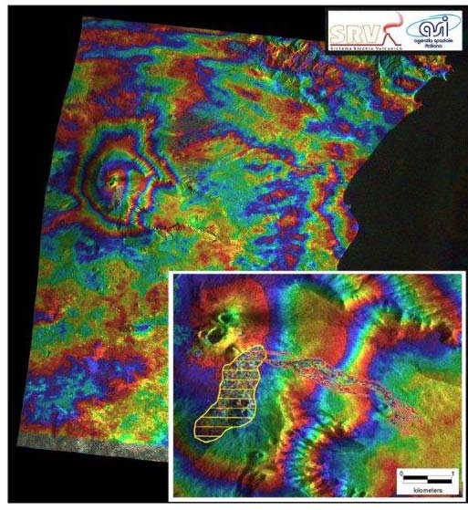
The COSMO-SkyMed satellites data, obtained on 12 and 13 January 2011, have been subject to computer analysis by the Institute for the Electromagnetic Sensing of the Environment (IREA) of the National Research Council (CNR), partners of the ASI-SRV team. An interferogram has been generated, which shows a general absence of deformation in the lower areas of the volcano and three interferometry fringes around the summit. The latter could be the result of the deformation effect associated with the deflation of the upper parts of the volcano, although a partial atmospheric component cannot be completely ruled out.
The deflation, recorded also by the INGV clinometric stations positioned at the edge of the deformed area, may have been produced by the rapid emptying of the magma chamber, caused by the violent emission of magma during the paroxysmal episode. A detailed analysis of the summit area highlights two completely separate areas: the first, with a East South-East direction (area in red), corresponds to the lava flow created during the paroxysmal event; the second, with a South South-West direction (area in yellow), has enabled the larger fallout deposits (thickness > 3cm) to be mapped, as confirmed by comparison with the data recorded on land.
The ASI-SRV System has also provided the Civil Protection Department, through the project webgis, with products obtained from the processing of optical AVHRR and MODIS data, such as the map of aerosol optical thickness (AOT), Temperature, Thermal Flow, Effusion rate and Plume SO2 content.
The main partner of the ASI-SRV project is the National Institute of Geophysics and Volcanology (Ingv). Also involved in the project, besides Irea-Cnr, is the University of Modena and Reggio Emilia, Advanced Computer Systems spa and Galileian Plus srl